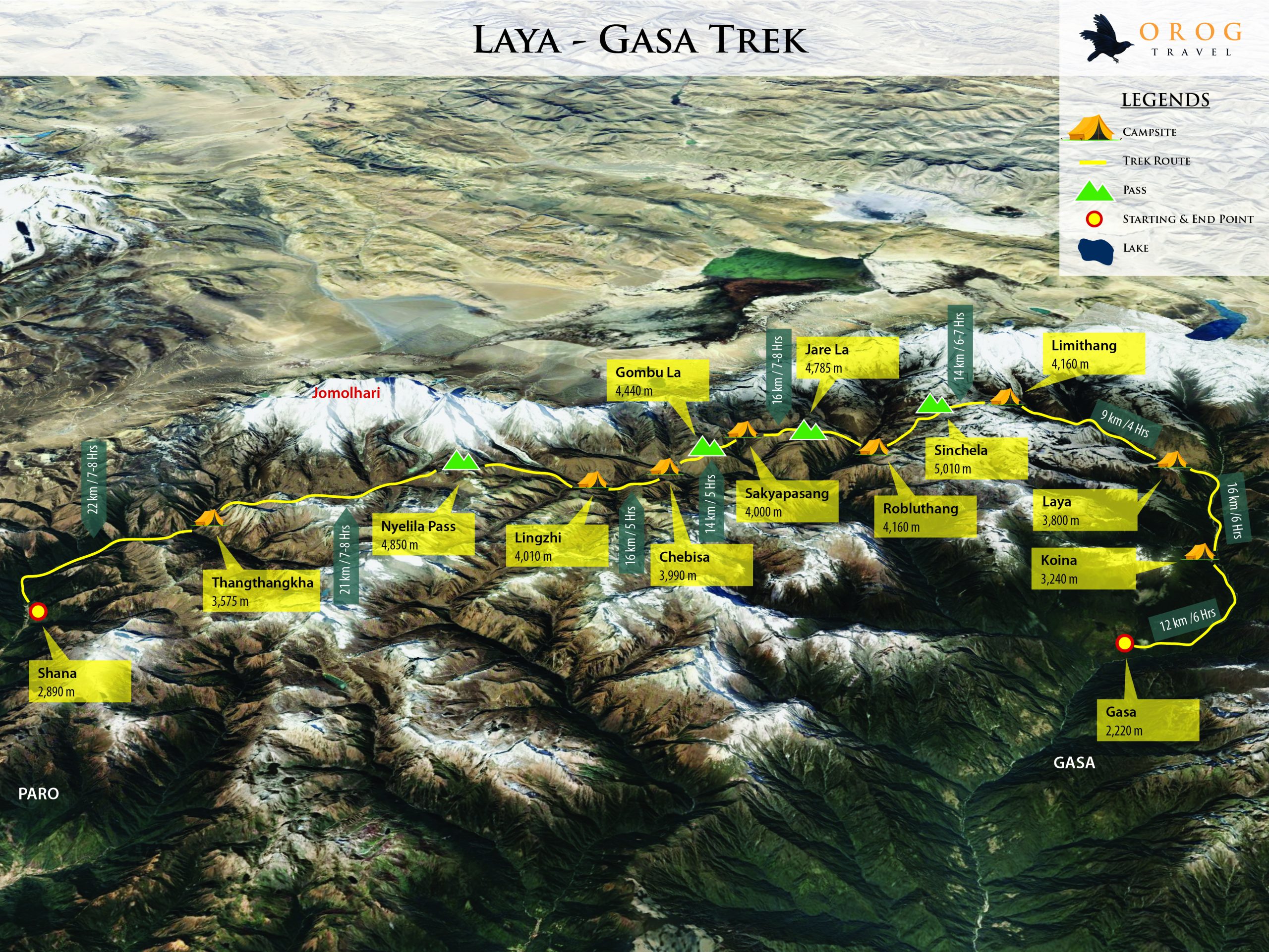
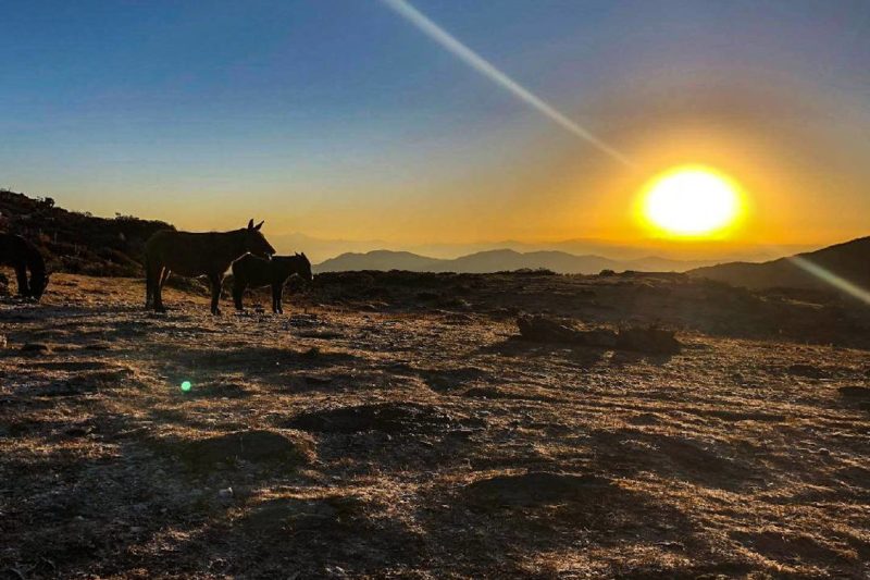
Considered to be most strenuous Bhutan treks, the Laya Gasa trail dominates the experience with picturesque destinations, through altitude ranges between 2,500m to nearly 5,000m. Starting from Paro, through scenic isolated mountain villages, striking alpine meadows, and magnificent waterfalls completing the trek in Gasa. Indulge in Bhutan’s pristine nature and experience spectacular views of the sacred Mt. Jhomolhari, Jichu Drake, Gangchhenta (Great Tiger Mountain. Have the change to spot the indigenous animals of Bhutan and the Himalayan region. Meet and learn about the Layaps – semi-nomadic yak herders who live in the northwest of Bhutan spending their time between their village and the high-altitude yak herding camps having their very own distinctive culture and heritage.
Recommended time to experience the trek from Late March to June and mid-September to mid-November with the finest views of Bhutan’s beautiful landscape and enormous mountains.
Altitude in Paro: 2,280m
Onboard the aircraft, the flight is treated to spectacular views of snow peaked mountains and the Himalayan ranges. Paro airport (2,280m) is Bhutan’s only international airport where our dedicated team will receive you at the airport.
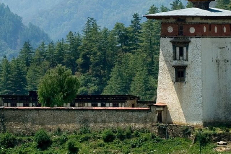
Paro Rinpung Dzong (Fortress of The Heap of Jewels)- Rinpung Dzong is an ancient fortress in traditional Bhutanese architecture with a complex of courtyards, temples, administration offices and open space surrounded by towering walls. All the buildings are equipped with huge windows with elaborate wooden carvings of traditional Bhutanese motifs. Paro Dzong is considered one of the finest examples of Bhutanese architecture and it’s one of the top tourist attractions in Bhutan. This impressive dzong is also seen during landing into Paro Airport.
Shagzo (Bhutanese woodturning at Sangay Wood Turning Factory) - The shagzo techniques use the age-old methods and each product is unique in shapes, sizes and colours. Learn the Shagzopa (Shagzo artisans), the essential steps in creating the elegant and functional products like wooden bowls (dapa), cups (dza phob) and plates with beautiful patterns, while keeping the ‘soul’ of the wood in it.
Altitude in Paro: 2,280m
Taktsang Monastery (Tiger’s Nest)- at 3,000m above sea level, this is one of the most sacred sites of Bhutan. It is believed that Guru Padmasambhava (Guru Rinpoche) came here on the back of a tigress in the 8th century. Lunch will be served at the Taktshang cafeteria and descend towards the Paro valley floor. The journey will take 6-7 hours in total.
Kyichu Lhakhang- one of the 108 temples built throughout the Himalayas by the Tibetan King Songtsen Gampo in the 7th century. The main chapel has roots as far back as the 7th century, with additional buildings and a golden roof added in 1839 by the penlop (governor) of Paro and the 25th Je Khenpo. Elderly pilgrims constantly shuffle around the temple spinning its many prayer wheels, making this one of the most charming spots in the Paro valley.
Distance: 20km
Estimated time: 8hrs
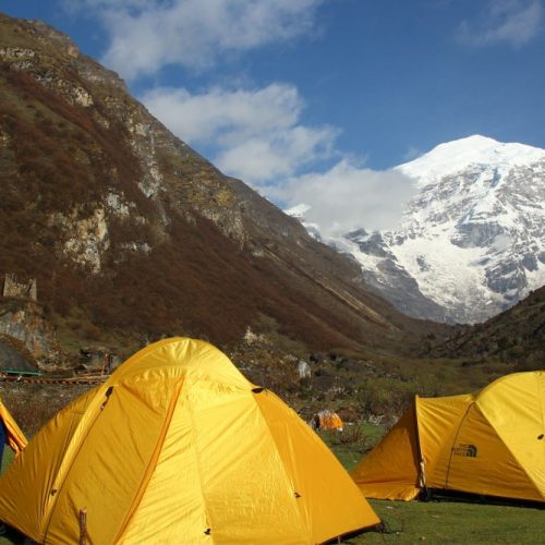
Camp altitude: 3,610m
Ascent 770m, descent 10m
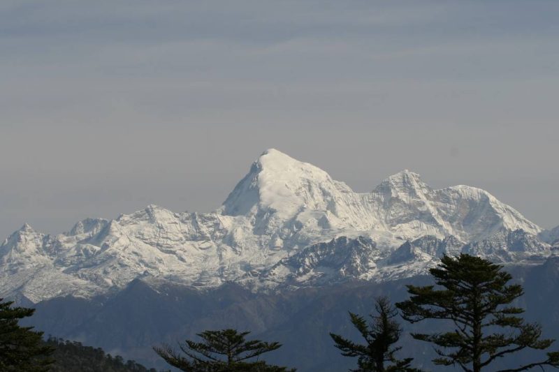
The trail consists of various ascends and descends across the valley and afterr crossing the river valley, the trek will continue down to a meadow where camp site is located at an altitude of 3,610m. On a clear day, the view of the Mt. Jomolhari (7,314m) will be visible in all its grandeur. The name translates to ‘Goddess of The Holy Mountain’, or ‘Goddess of The Mountain Pass’, considered to be a sacred mountain by the Bhutanese.
Distance: 19km
Estimated time: 6hrs
Camp altitude: 4,080m
Ascent 480m
Passing through the dense forest for approximately an hour and continuing along the river until the army checkpoint at an altitude of 3,730m.
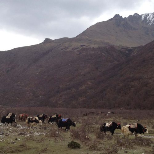
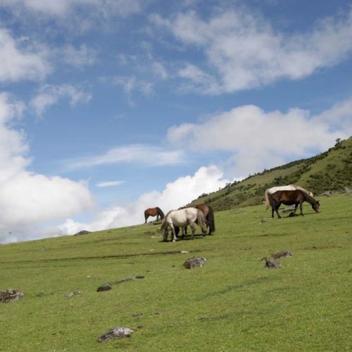
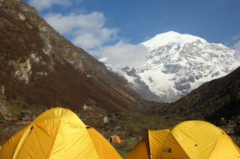
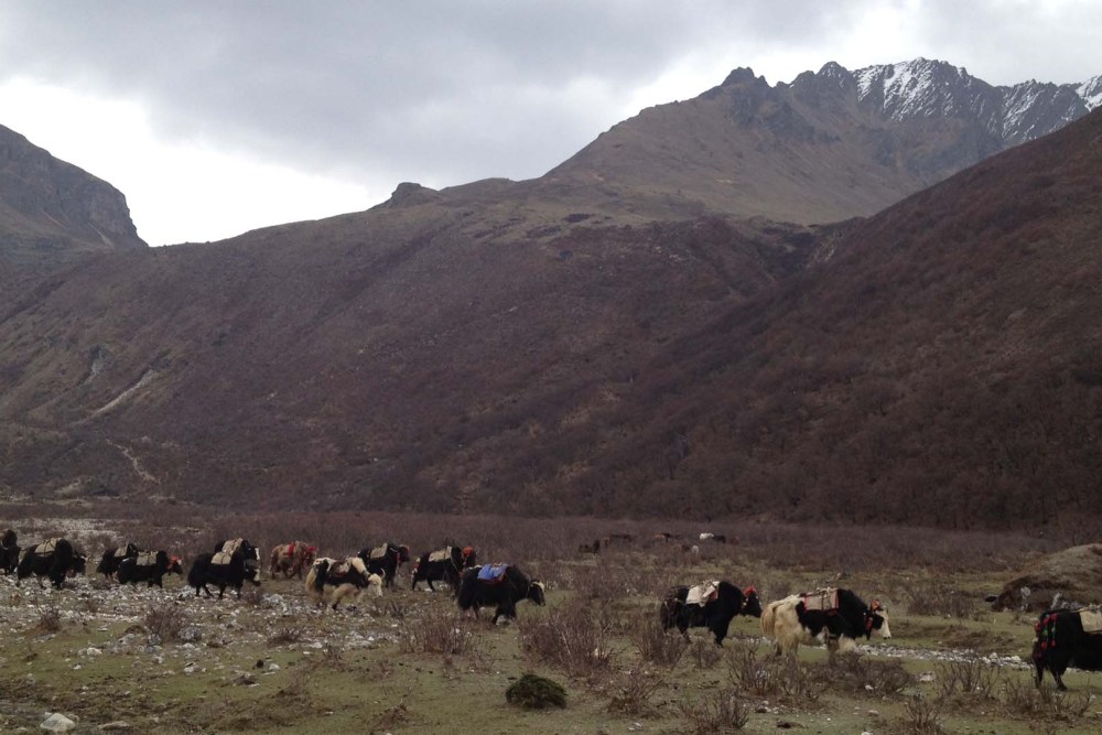
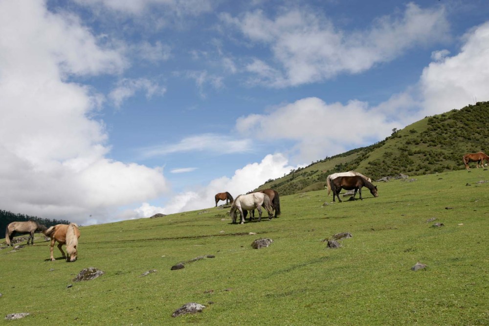
This area is often home to yaks and the yak herders. Before reaching the Jangotang campsite, a few villages will need to be passed and a climb up the mountain. Jangothang is one of the most scenic campsites in Bhutan with spectacular campsite view of Mt. Jomolhari from a different perspective.
Take a rest day at Jangothang will have with acclimatization. It provides plenty of possibilities for day hikes with great views of lakes and snow-capped mountains such as Jomolhari and Jichu Drake. There are good chances to spot some blue sheep on the upper slopes of the valley. Trek up to Tosoh lake or hike around the area is also possible. There are good short hiking trails in three directions. Jomolhari and its subsidiary mountain chains lie directly west, Jichu Drake to the north and there are a number of unclimbed peaks to the east.
Distance: 18km
Estimated time: 7-8hrs
Camp altitude: 4,010m
Ascent 840 m, descent 870 m
Considered to be one of the longest sections of the trek, the trail continues northward, followed by a steep climb for about half an hour until Nyilila pass at 4,870m. Herds of blue sheep grazing along the slopes of the mountain can be seen at this point along with views of Mr. Jitchu Drake.
The descend then leads to the camp passing by some of the yak herder’s tent gradually arriving atLingshi basin, a charming U-shaped valley. If the weather permits, a wonderful view of Lingshi Dzong and Tserimgang and its glaciers at the north end of the valley is seen. Campsite will be next to a stone hut at close proximity from Lingshi Dzong.
Distance: 10km
Estimated time: 5-6hrs
Camp altitude: 3,880m
Ascent 280m, descent 410m
This section of the trek will be an enjoyable experience on a wide trail high above on the valley floor. Detour to the Lingshi Dzong is an option or continue on the mail trail.
A visit to the dzong with provide a view of the picturesque valley. An hour’s gradual climb will bring the trail to a cairn with some prayer flags on Talela ridge (4,100m), Nyilila pass and Mount Jitchu Drake will be visible at this point.
The trail descends towards a side valley, through Lingshi and Goyul villages. Houses in Goyul are made of stone and clustered together, which is uncommon for Bhutanese houses, making it an interesting sight. Additionally, there is Ja Goed Dzong located in Goyul village, worth a visit as it is one of the four temples built by Phajo Drugom Zhigpo, one of the most sacred temples in Bhutan.
Campsite at Chebisa village after another hour of trekking, located close to a waterfall behind this small village.
Distance: 17km
Estimated time: 6-7hrs
Camp altitude: 4,220m
Ascent 890m, descent 540m
The trail from Chebisa village will start with a long ascent through a wide grassland, leading to Gobu La pass (4,410m). During the hike, large herds of blue sheep or herders with their yaks can be spotted. Crossing Gobu La pass, the trek will descend gradually to Shakshepasa (3,980m), a large beautiful U-shaped valley. Climbing the valley, campsite is located at Shomuthang above the river, which is a tributary of the Nochu river.
Distance: 18km
Estimated time: 6-7hrs
Camp altitude: 4,160m
Ascent 700m, descent 760m
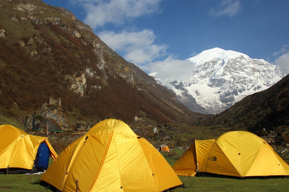
A climb up the valley to observe Kang Bum Mount (6,526m) and lovely edelweiss (a flower which only found in remote mountain areas). Continuing with two hours of hike which leads to Jhari La pass (4,750m) providing views of Sinche La pass- the hike for the next day. To the north is a stunning snowy peak, which is a part of Gangchheta (Great Tiger Mountain). On a clear day, the Tserim Kang along with top of the Jomolhari Mount will be visible. The campsite by the river Tsheri Jathang, is located in a wide and alluring valley. In the summer, herds of Takin – Bhutan’s National Animal will migrate to this valley and stay for about 4 months. Thus, the valley is now a takin sanctuary. Campsite at Robluthang is a brief climb away.
Distance: 19km
Estimated time: 6-7hrs
Camp altitude: 4,140m
Ascent 850m, descent 870
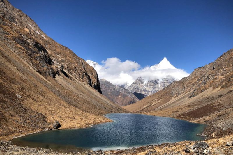
This section of the trek will be more challenging. At the start of the hike, a number of small streams will be crossed and a gradual climb up through a boulder field for about 1.5 hours. A steep ascent for another hour to reach Sinche La pass (5,005m). This is the highest pass on this trek. At the foot of the valley, the sight of an impressive terminal moraine and a glacier lake to the far side of Sinche La pass is seen. To the northeast of this pass, the glorious Mt. Gangchhenta. This massive mountain is covered in snow and ice, rising to a remarkable height of 6,840m.
Kango Chhu will need to be crossed passing through lush cedar forests arriving at Limithang campsite (4,140m). From campsite the peak of Gangchhenta towers into view.
Distance: 10km
Estimated time: 5hrs
Camp altitude: 3,840m
Ascent 60m, descent 340
The trek begins with the only brief ascent followed by downhill trekking along a narrow, winding river valley before crossing a dense forest. The trek leads from the west side of Laya village. Views of both Mt. Gangchhenta and Mt. Masagang continue to have its presence along the trek. The campsite will be located below the community school.
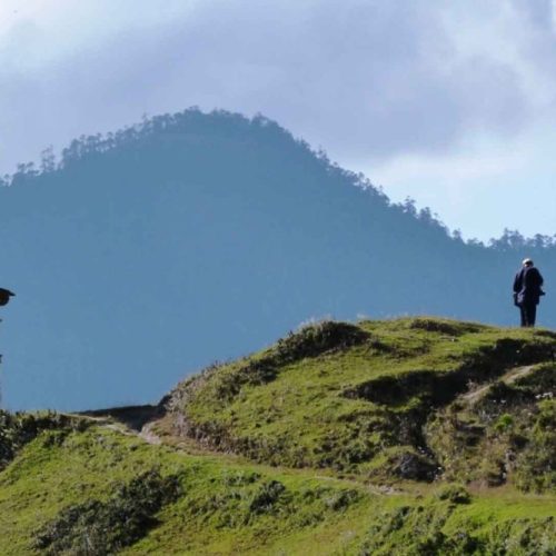
A rest day with options to explore Laya village and meet with the local people. An opportunity to learn about the life of the Bhutanese in this region.
Laya Culture- Distinctive dress of the Layap women, which is made of yak hair and sheep’s wool. The attire includes a black skirt with brown vertical stripes, a black jacket (khenja) and a unique conical bamboo hat with decoration hanging at the back.
In Laya, women tend to look after the yaks, and weave, and they also weed, harvest, and thresh. Layap men are often engaged in trading and responsible for plowing the fields with the yaks.
Try the traditional hot stone bath- The wooden boxes are partly buried in the ground, filled with water, sometimes herbs are added in for health purposes. The water is heated water using stones that are heated in wood burnt fire.
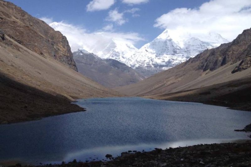
The village is located close to a number of holy lakes, which are Kharkhil Tscho, Paro Tsho, and Oneme Tsho, in the area of Chhuton Chhagari. Enjoy the views of these crystal-clear lakes and pristine nature of the area. The lakes, surrounded by green meadows, are always a nice change of scenery from the colossal mountain ranges during the trek. Another option is also to visit the hot springs at Lungo village.
Distance: 19km
Estimated time: 6-7hrs
Camp altitude: 3,050m
Ascent 260m, descent 1,070m
The next campsite will be located at a lower altitude and the descend is gradual towards the next stop. The trek will switch between ups and downs before taking on a steep descent throughout the day.
Campsite is located in Konia which is reached after passing Kohi Lapcha pass at an altitude of 3,300m.
Distance: 14km
Estimated time: 6-7hrs
Camp altitude: 2,240m
Ascent 740m, descent 1,500m
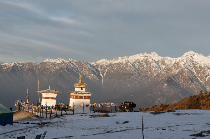
The road will lead us to cross Bari La pass (3,740m), then to Gasa village (2,770m). From here, it will be another hour of trekking to the famous Gasa Tsachu (hot springs)- a chanve for rejuvenating mineral water. The Gasa Tsachu is one of the most renowned hot springs in the country. Campsite is located close to Gasa Dzong.
Altitude in Punakha: 1,300m
Pick up will be organized at this point and transfer to Punakha, which is 70km away from Gasa. You will arrive in Punakha after 3 hours of driving.
Sangchhen Dorji Lhuendrup Lhakhang Nunnery- Perched on a hilltop overlooking the beautiful Punakha and Wangduephodrang valley.
Surrounded by rich lush green pine forest the nunnery complex is a true expression of Bhutanese architecture portraying strong traditional values.
Punakha Dzong (Palace of Great Happiness)- Built-in 1637, it is said to be the most spectacular dzong in Bhutan. Punakha Dzong was built at the confluence of two major rivers in Bhutan, the Pho Chhu and Mo Chhu, which converge in this valley.
In addition to its structural beauty, until the mid-1950s, it still served as Bhutan’s capital and the seat of the government. All of Bhutan’s kings have been crowned here, and it has witnessed the memorable wedding of the King of Bhutan, Jigme Khesar Namgyel Wangchuck to Jetsun Pema in 2011.
Pho Chhu Suspension Bridge- Measuring at 160m in length, this is Bhutan’s longest suspension bridge. Spectacular sight of Punakha Dzong and Pho Chhu Valley.
Khamsum Yulley Namgyal Chorten (1,500m)- A leisure 1 hour hike to witness Bhutan’s finest example of tradition and architecture. A unique attribute of this Chorten setting it apart from the rest is in its architecture- designed on the principals delineate within the Holy Scriptures instead of trendy engineering manuals. The golden spire and labyrinthine wall patterns square measure fine example of art and traditions
Altitude in Paro: 2,280m
Distance: 125km
Estimated travel time: 4hrs
Chimi Lhakhang- Hike to the Temple of Fertility (altitude: 1,500m). An enjoyable hike, taking about 30 minutes through the rice and mustard fields and the uniquely decorated houses of Lobasa Village.
Dochula Pass (3,050m)- Panoramic view of the Himalayan mountains. The pass is a popular location among tourists as it offers a stunning 360 degree panoramic view of the Himalayan mountain range. The view is especially scenic on clear, winter days with snowcapped mountains forming a majestic backdrop to the tranquility of the 108 chortens gracing the mountain pass.
National Memorial Chorten – one of Bhutan’s most prominent buildings. The Chorten is the monument of world peace and prosperity. For Bhutanese, the site also serves as the memorial to their Third King, His Majesty Jigme Dorji Wangchuck (1928-72).
Buddha Point (Buddha Dordenma) - At a height of 51,5m, placed on top of a hill in Kuenselphodrang Nature Park, the sight of the enormous statue of Shakyamuni Buddha is stunning and unforgettable. This giant statue is one of the largest in the world and is said to emanate an aura of peace and happiness.